What is my research? |
I combine the study of active tectonics with surficial processes to infer and characterize crustal deformation at different time scales.
I investigate crustal deformation through the characterization of active tectonic systems and their evolution through time and space, combining different approaches, such as detailed structural geology mapping, paleoseismology, tectonic geomorphology, geophysical data, and remote sensing analyses. I am also interested in natural hazards, in particular the ones related to earthquakes.
I study seismic sources, earthquakes, and surface deformation, trying to provide evidence for the understanding of seismic cycles.
To quantify the deformation and surface process rates and timing of events, I apply geochronology methods, namely Terrestrial Cosmogenic Nuclides, and Optical Stimulated Luminescence techniques both of which I hold comprehensive knowledge.
My research frequently integrates 3 main lines:
- 1) Active Tectonics/Neotectonics and Tectonic Geomorphology;
- 2) Earthquake Geology and Paleoseismology;
- 3) Geochronology, namely Luminescence and Terrestrial Cosmogenic Nuclides (10Be, 26Al, 36Cl).
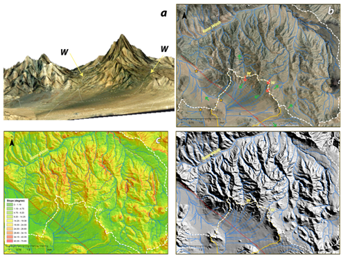
I combine geological mapping and structural geology with detailed geomorphic analyses to recognize cumulative deformation in the landscape, and quantify tectonic slip-rates. This takes into account investigating locations where evidence of deformation is better preserved.
I combine geological mapping and structural geology with detailed geomorphic analyses to recognize cumulative deformation in the landscape, and quantify tectonic slip-rates. This takes into account investigating locations where evidence of deformation is better preserved.
|
|
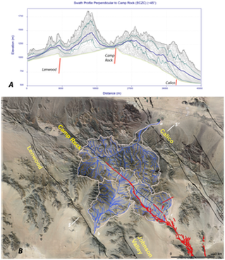
Above, is an example of drainage piracy and wind gaps along the Camp Rock fault (Eastern California Shear Zone), which conditions the preservation and age of landforms allowing their use as markers for fault activity to estimate past slip rates (Figueiredo et al., 2019, oral presentation at AGU; Figueiredo et al. in prep.).
I use remote sensing (frequently Lidar) to identify and map past surface ruptures (below left image, 1915 Mw 7.3 rupture Pleasant Valley, Nevada, scarps meters height) or to track recent and subtle surface ruptures (below right image, 2020 Mw 5.1 rupture Sparta, North Carolina, scarp few cm to ~30 cm height).
|
|
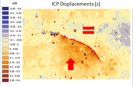
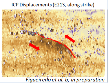
The use of Lidar also allows for characterization of deformation per earthquake: here I apply a 3D deformation analysis combining lidar datasets pre and post earthquakes. This example was made for the 2020 Mw 5.1 Sparta, North Carolina earthquake.
|
|
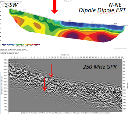
Deformation zones can be highlighted by geophysical surveys. When possible I combine sub-surface geophysics with the geology and geomorphology information, allowing to constraint precise locations for the active fault strands, and later investigate for evidence of past surface rupture earthquakes.
To the left, an Electrical Resistivity Tomography (ERT) and Ground-Penetration Radar (GPR) across the 2020 Mw 5.1 Sparta, North Carolina surface rupture, showing the unknown reverse fault that ruptured. This fault is now called Little River fault. Paleoseismology studies demonstrated previous surface ruptures, corroborating the existence of an active fault with long recurrence periods in the Blue Ridge, in the Appalachians (Figueiredo et al., in preparation).
Active Research:
- Precariously Balanced Rocks in the Eastern US applied to maximum ground shaking;
- The 2020 Mw 5.1 Sparta, North Carolina earthquake;
- Nevada (Walker Lane and Pleasant Valley Fault paleoseismology and long term deformation rates);
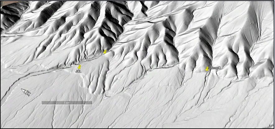
- Eastern California Shear Zone (Camp Rock Fault and Calico faults);
- Quaternary faults in Portugal and Iberia landscape evolution;
- Southern California:
- Cajon Pass, convergence of the San Andreas and San Jacinto fault systems, revisiting the soil chronosequence of the Pleistocene surfaces and deposits displaced and obtaining geochronology data
- Mecca Hills, quantifying ages of landforms with cumulative displacement for recent times, differentiating seismic from aseismic slip
-central Banning Fault (San Andreas fault system) slip-rate using geochronology, detailed geomorphology and sub-surface data
- Precariously Balanced Rocks in the Eastern US applied to maximum ground shaking;
- The 2020 Mw 5.1 Sparta, North Carolina earthquake;
- Nevada (Walker Lane and Pleasant Valley Fault paleoseismology and long term deformation rates);
- Eastern California Shear Zone (Camp Rock Fault and Calico faults);
- Quaternary faults in Portugal and Iberia landscape evolution;
- Southern California:
- Cajon Pass, convergence of the San Andreas and San Jacinto fault systems, revisiting the soil chronosequence of the Pleistocene surfaces and deposits displaced and obtaining geochronology data
- Mecca Hills, quantifying ages of landforms with cumulative displacement for recent times, differentiating seismic from aseismic slip
-central Banning Fault (San Andreas fault system) slip-rate using geochronology, detailed geomorphology and sub-surface data
